Created by Tickie Bindner at ECAL, Sazen City is a digital collaborative platform designed to stitch shared memories into a cohesive digital landscape. By integrating both individual and collective experiences in the form of postcards, the project seeks to create a dynamic, ever-evolving cityscape.
The project started as an interest in the dynamic interplay between physical and digital spaces. The research aimed to create imaginative environments, investigating the connections between digital realities and urban landscapes through new narratives. Inspired by Italo Calvino’s Invisible Cities, Sazen City employs machine learning to co-create a shared territory. As it evolves, this shared landscape questions the individuality of our memories and the role of artificial imagination in our digital environments.
During the process, I noticed that the images, though the locations are abstractly generated, evoke a sense of familiarity for many. People from diverse backgrounds (and cities) perceived these images as reminiscent of known places. This led me to the notion of “universal memories” – visuals tied to nowhere specifically, but that bring back shared souvenirs. I think our souvenirs are deeply tied with emotions, and the experience on my website feels like wandering through a collection of not-so-individual memories.
Tickie Bindner
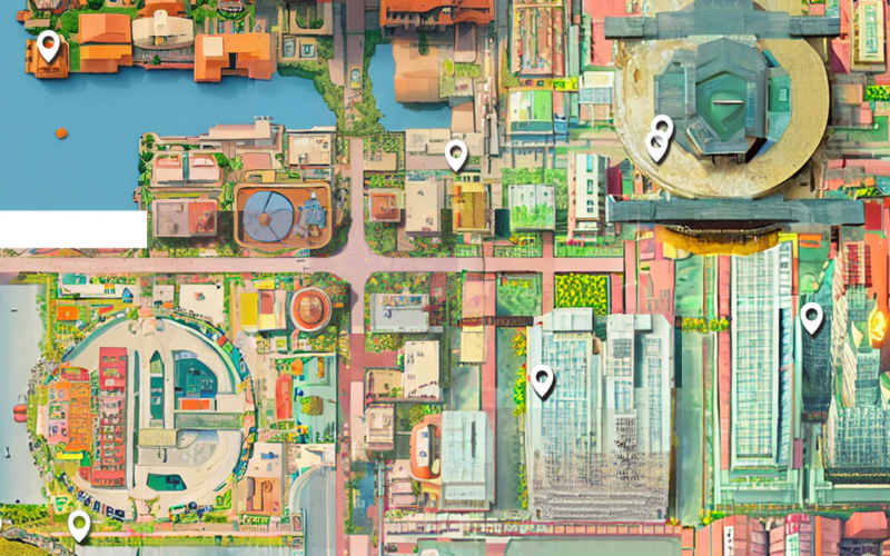
Participants start by placing a pin on the virtual map. Based on the topography of this area, a unique image is generated. This is achieved by capturing a snapshot around the selected pin location. Most of this image is then erased as a base for DALL-E inpainting, slightly changing the prompt to another perspective – the street view or postcard one. This process creates the impression for the user that the postcard authentically represents its surroundings. This phase is individual for each user. Users can customise the text on the back of the postcard by selecting a desired ending, allowing for a personalised narrative. The words are more than simply descriptive; they are later used as prompts to expand the map for everyone.


Once a postcard is generated and sent, the experience becomes collective. Using Firebase, relevant postcard details are stored, and the created postcard is delivered to another random user. This collective map growth is powered by Stable Diffusion. The landscape constantly reshapes and expands as users engage with the platform by placing pins, generating postcards, and sharing them. No two interactions produce identical outcomes, ensuring the cityscape is always unique. If users don’t exchange the postcards, the map remains static in its current state. The most recent user’s postcard influences each newly formed neighbourhood on the map. While users play a direct role in shaping the map’s visuals, the process is designed to be more nuanced and poetic than a straightforward prompt. It’s about shared influence rather than direct input.
The prompt, which is expanding the map for everyone, is an invisible layer, under the city map. This is essentially a colour-coded map with distinct zones, where RGBA values correspond to specific descriptive words for various terrains:
Red Zone
Urban downtown landscapes with grid-like streets, plazas, and subway lines.
Green Zone
Rural settings with fields, forests, and farmhouses.
Blue Zone
Coastal areas with beaches, rivers, and lakes.
Alpha Zone
Experimental terrains with unique architecture and altering landscapes.


When pins are placed on the city map, words associated with the corresponding colour zone from the prompt map influence the generation of the following postcard and neighbourhood.


The postcard generation uses DALL-E 2 API through Node.js. While “topography” might not be the exact term in the traditional sense, the close surroundings of where the pin is dropped are being used. This primarily refers to the colour palette and specific elements – words – from the hidden prompt map. Then, elements from the user-generated postcard and the prompt map initiate the second phase of the experience: the creation of the next neighbourhood. To achieve this, Stable Diffusion is used through Replicate, a platform that simplifies the application of open-source models. This model provides more powerful in-painting & out-painting capabilities.


Unlike photos of panoramas or cities, these digital cards depict memories, universal moments and emotions, revealing a new epistolary exchange more suited to our digital spaces. By using machine learning to collaboratively shape a shared digital landscape, this collective space questions the uniqueness of our memories and explores the impact of artificial creativity in our online world.
Project Page | Tickie Binder | ECAL — Media & Interaction Design


/++
/++